
Walks in and around Bradfield
Bradfield is one of the largest parishes in England, and covers extensive moor and agricultural land around the Damflask Reservoir, Dale Dike Reservoir, Strines Reservoir, and Agden Reservoirs, including the Bradfield, Midhope, and Broomhead moors and eastern parts of the Howden moors.
The western end of the parish reaches to the upper parts of the Upper Derwent Valley with part of its boundary forming Yorkshire’s border with Derbyshire. The northern part of the parish includes the Langsett reservoir and Midhope reservoir, and borders the town and civil parish of Stocksbridge.
The eastern edge reaches the western extent of the urban spread of Sheffield, and includes the suburb of Stannington, as well as the villages of Oughtibridge, Wharncliffe Side, and Worrall. Minor habitations within the parish include Midhopestones, Upper Midhope on the northern edge, and Dungworth in the southeastern part.
The moorland villages of High Bradfield and Low Bradfield are located within the parish. High Bradfield possesses a Gothic revival church, and the earthworks of a motte and bailey castle. Low Bradfield is less historic, having been largely destroyed in the Great Sheffield flood of 1864. (Source: Wikipedia).
The source for all these walks is the excellent Bradfield Walkers are Welcome website, www.bradfield-walkers.org.uk, who have kindly allowed us to feature text and images from their site and leaflets. There are plenty more walks to choose from at the actual site.
Bradfield Walks
Bradfield Loop
Source: Bradfield Walkers are Welcome.
Length - 5.3 miles.
Time: 3 hours.
A walk from Low Bradfield to High Bradfield and Agden Reservoir. From Low Bradfield the route climbs through fields to High Bradfield, then passes St. Nicholas' Church and Bailey Hill and continues through woodland before crossing more open land. The final section is by Agden Reservoir.
Grade: gentle ascents, one steep descent, can be muddy in place. Most paths well defined.
Parking: Car park, The Sands, Low Bradfield.
Public transport: buses 61 / 62 stop at Fair House Lane / Smithy Bridge Road, Low Bradfield.
Refreshments - The Post Card Café, The Plough Inn, Low Bradfield; Old Horns Inn, High Bradfield.
Public Toilets -Low Bradfield.
For detailed information and map please visit www.bradfield-walkers.org.uk/Walks/BradfieldLoop.html
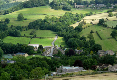
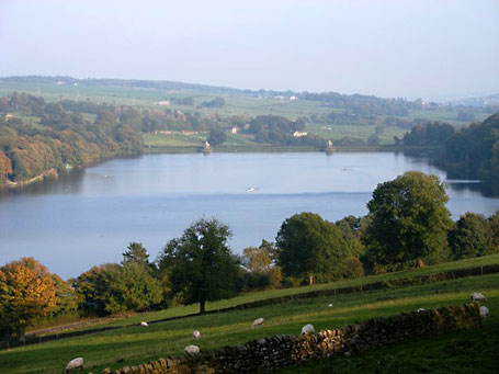
Photo: Agden reservoir (Bradfield Walkers).
Two Villages
Source: Bradfield Walkers are Welcome.
Length - 1.8 miles.
Time: 1 hours.
A short walk from Low Bradfield to High Bradfield and back.
Grade: gentle ascents, one steep descent, can be muddy in place. Most paths well defined.
Start / Parking: Car park, The Sands, Low Bradfield .
Public transport: buses 61 / 62 stop at Fair House Lane / Smithy Bridge Road, Low Bradfield.
Refreshments - Old Horns Inn, High Bradfield; The Postcard Café and The Plough Inn, Low Bradfield.
Public Toilets -Low Bradfield.
For detailed information and map please visit www.bradfield-walkers.org.uk/Walks/TwoVillages.html
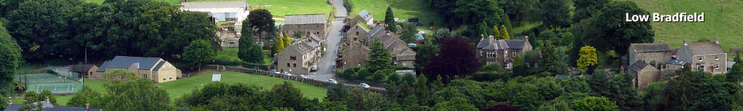
Photo: Low Bradfield (Mick Knapton/Wiki Commons).
Damflask Reservoir
Source: Bradfield Walkers are Welcome.
Length - 3.8 miles.
Time: 2 hours.
A circular walk around Damflask Reservoir.
Starting in the village of Low Bradfield this circular easy access route gives ample scope to enjoy long stretches of woodland and waterside. The route also offers panoramic views across Damflask Reservoir.
When the Dale Dyke dam burst at midnight on 11th March 1864, Damflask village was almost entirely destroyed. The village was not rebuilt after the flood as plans were already in place to build a reservoir. Damflask reservoir today has a capacity of 1,123 million gallons, with a maximum depth of 88 feet. Nowadays it is used by rowing and sailing clubs and also for fishing.
Grade: level and easy to find.
Start & Parking: car park / bus stop, The Sands, Low Bradfield.
Public transport: buses 61 / 62 stop at Fair House Lane / Smithy Bridge Road, Low Bradfield.
Refreshments - The Postcard Café and The Plough Inn, Low Bradfield.
Public Toilets -Low Bradfield.
For detailed information, map and a history of the lost village of Damflask, please visit www.bradfield-walkers.org.uk/Walks/Damflask.html
Photo: Damflask Reservoir(Geograph.co.uk/Wiki Commons).
Ughill Moor
Source: Bradfield Walkers are Welcome.
Length - 8 miles.
Time: 4 hours.
A walk around Dale Dike Reservoir and Ughill Moor.
Grade: a short section on roads, then farm tracks and well defined paths. Boggy in places. Steady ascent of 700 ft over 2.5 miles.
Start: car park on Mortimer Road, 300m North of the Strines Inn, Bradfield, Sheffield S6 6JE.
Parking: As above. If the car park is closed for forestry work, park on the road, North of the car park by the path down to Strines Reservoir.
Public transport: none close to the start point. The nearest bus stop is in Low Bradfield. Go up Fair House Lane, Dale Road and pick up the route at the entrance to Dale Dike Reservoir.
Refreshments - none on route. Nearest are the Strines Inn, Mortimer Road; The Post Card Café, Plough Inn, Low Bradfield; Old Horns Inn, High Bradfield.
Public Toilets -Low Bradfield.
For detailed information, map and a history of the lost village of Damflask, please visit http://www.bradfield-walkers.org.uk/Walks/UghillMoor.html
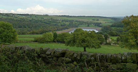
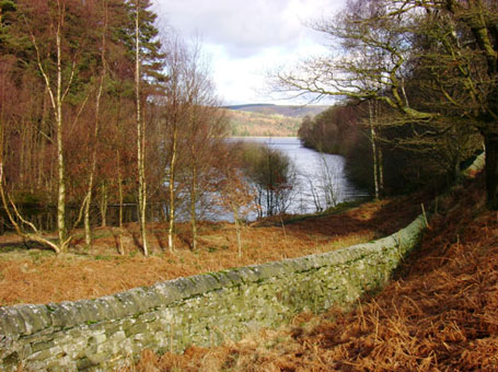
Photo: View across Dale Dike Reservoir (Bradfield Walkers).
Other walks and sites
The above routes are all taken from the Bradfield Walkers are Welcome website whch features a diverse range of walks. There is also a guided walks section which features a new walk roughly every month.
The equally good Stockbridge Walkers are Welcome site offers similar information: geographically, there's some overlap between the two sites' walks so it's worth exploring both. Some of the walks in the walks in the Steel to Stone website also fall within the parish of Bradfield. Walks from both these sites are featured in our Stockbridge section.
Reservoirs in the area are maintained by Yorkshire Water; their website includes walks and other activities in the area.
Wheely Easy Walks
Bradfield Walkers are Welcome group were awarded a grant in August 2011 from the Sheffield City Council 50+ Small Sparks for Older People fund to investigate routes in the Bradfield area suitable for mobility-impaired walkers, especially users of wheelchairs and mobility scooters.
As a result of feedback from users and visits to the area to assess routes, a leaflet has been produced to allow those wishing to enjoy Bradfield’s countryside to judge the suitability of routes for themselves taking into account their particular circumstances and local conditions.
You can download the leaflet from the Bradfield Walkers are Welcome home page.