
Walks in and around Penistone
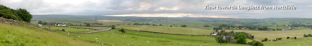
Penistone is the highest market town in England (750ft/230m above sea level) and lies in the foothills of the Pennines. The highest point in the surrounding area is at Hartcliffe Tower at 1,194 ft (364 m) above sea level, which has views over the Woodhead bypass and the Dark Peak.
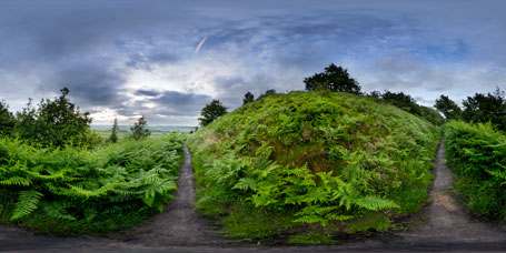
The surrounding countryside is predominantly rural with farming on rich well-watered soil on mainly gentle slopes rising to the bleak moorland to the west of the town centre. Dry stone walls, small hamlets and farms surrounded by fields and livestock are synonymous with the area. The area is also known for its rugged breed of sheep, the Whitefaced Woodland. (Wikipedia.)
The town itself is steadily expanding; the new, award winning Market/Cruck Barn is the largest public oak-framed building in the country and is rapidly becoming a popular venue for a variety of events.
Penistone Walks
Penistone Boundary Walk
Distance:
15 miles (as calculated by Google Maps)
Places on the route or nearby:
Cubley, Penistone, Hoylandswaine, Scout Dyke Reservoir, Moor Royd Reservoir, Millhouse Green, Bullhouse, Hartcliffe (and tower).
Facilities: Parking, refreshments and the usual facilities can all be found at cubley Hall.
Links and other info:
Click here for a low-resolution version of the narrative and original leaflet's map.
Click here for a high-resolution version of the narrative and original leaflet's map.
Please note that the orginal leaflet is now out of print although the text and the map in the PDFs is lifted directly from it.
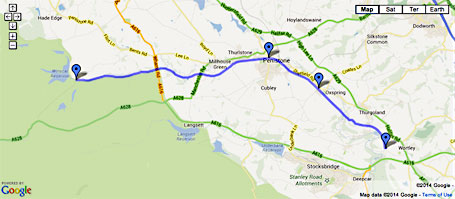
View the Penistone Boundary Walk as a larger map on the main Google site. Photos taken in the area are also available on that page - click the drop-down menu (starts with "traffic") on the right of the map for more options.
You can also view parts of the route in Google Street View - click here for a guide on how to use Street View.
Dunford Bridge to Wortley (Transpennine Trail via Penistone)
Distance:
10.1 miles
Places on the route or nearby:
Dunford Bridge, Hazlehead, Bullhouse, Millhouse Green, Thurlstone, Penistone, Springvale, Oxspring, Thurgoland, Wortley.
Facilities: Toilets at Winscar Reservoir (near Dunford Bridge); toilets and shops in Penistone and Wortley.
MAP: click here to see the route in Google Maps. As with the map above, you can also see photos of the area and enter Street View for a virtual tour. Click here for a guide on how to use Street View.
The entire route is very easy to follow and is essentially one track all the way through to Wortley.
Starting at Dunford Bridge, you'll pass through Bullhouse, Millhouse Green, Thurlstone, Penistone, Oxspring and Thurgoland and reach picturesque Wortley.
Attractions at wortley include the Forge, Church and Wortley Hall.
Links and other info:
For more information about the Trans Pennine Trail visit the official website, www.transpenninetrail.org.uk
An illustrated PDF about this section of the walk (from which some of this information has been taken) can also be found on the TPT site.
Penistone from Underbank, Stocksbridge
Source: http://www.stocksbridge-walkers.org.uk/Walks/Penistone.html
Length - 10.5 miles
A long walk from Stocksbridge to the market town of Penistone. The first section of the route follows the railway line used in the construction on Langsett reservoir. The route then climbs across by Hartcliff Hill before dropping down to the Trans-PennineTrail at Ecklands. The route follows the trail through Thurlstone to Penistone and on past Oxspring before heading back to Stocksbridge over Snowden Hill.
Grade: mostly well defined paths, Trans-Pennine trail, stiles and steady ascents
Start: Unsliven Road, Stocksbridge Grid Reference - SK25405 99128
Parking: on-street parking, Unsliven Road.
Public transport: Unsliven Road stop, 57
Refreshments: cafes, pubs and shops in Penistone Public Toilets – Penistone, near the church.
For full route information and illustrated PDF, please visit http://www.stocksbridge-walkers.org.uk/Walks/Penistone.html
(Text - Stocksbridge Walkers).
The Pen-Den Trail
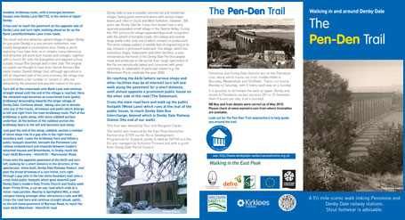
Source: www.denbydale-walkersarewelcome.org.uk
Length - 5.5 miles
A scenic walk linking Penistone and Denby Dale railway stations.
Transport: Penistone and Denby Dale stations are on the Penistone Line, along which trains run from Huddersfield to Barnsley, Meadowhall and Sheffield.
MAP: click here to view a Google Map of the walk.
Both the towns of Denby and Penistone are worth visiting in their own right and this walk between the two is a great way to see the surrounding countryside.
Other nearby walks
The following walks on other sites may also be of interest. Each link opens in a new window.
- Cawthorne Circular
- Ingbirchworth Reservoir Circular
- Nabs Wood, Silkstone Common
- Oxspring Millennium Walk
Other websites
These websites are also worth a closer look.
Jeff's Wheelchair Walks features short walks in the region suitablefor wheelcahir users including Canon Hall in Cawthorne.
Public Transport
You can plan transport to the start points by going to the Travel South Yorkshire Journey Planner which includes information for both trains and buses.